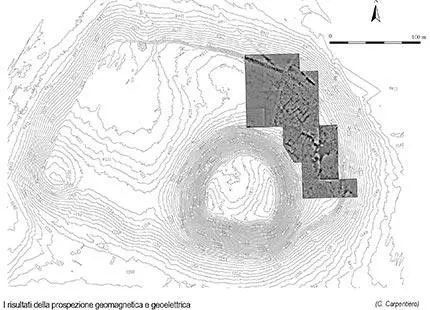
Geophysical survey
Magnometric and geoelectric prospecting provided us with information relating to the presence of numerous buried structures.
In the north-eastern section of the terraces there are anomalies that can be related to two large buildings. Building I, to the north, has a seemingly regular floor-plan and consists of long, narrow, rectangular, rooms. To the south, Building II is larger, with thicker external walls and a more complex plan apparently on differing levels which could extend over most of the eastern terrace. The granite blocks visible on the surface (Building I) most probably belong to the north-eastern wall of this structure.
Also clearly visible from the survey is a structure with two or three rows of parallel rooms occupying an area somewhat beyond the north-eastern terrace and seemingly characterised by the thickness of its north-eastern wall. Its position and plan enable us to identify it as a gateway between rows of rooms to either side which could be a casemate wall.
Other anomalies can be seen in the northern sector of the terrace and would appear to indicate a building with one or two rooms, oriented north-south, and with relatively thick wall (on the surface a Hittite clay seal impression was found). All of the south-eastern part of the eastern terrace is occupied by what seem to be isolated construction, whilst in the north-western sector the structures are more difficult to interpret but, given their density and complexity, these could relate to different phases of occupation.
The geomagnetic survey of the summit of the mound has revealed a circuit of walls dating to the late period. On the southern side, the large Building II is visible, consisting of wings of large rooms and courtyards. At the foot of the mound, the geomagnetic survey revealed the presence of a large, rectilinear anomaly which it is difficult to interpret (a wall or an outcrop of natural rock).


